Cool Engineering

Info on some cool engineering projects

Tuesday, October 31, 2006

A view from the air


Ok, my next photo is up to be voted on. This was on of the photos taken onboard the plane at an altitude of about 100m. If you are impressed (you should be) please vote for the photo.

What does Simplex (and half duplex) really mean?

In communications engineering there are three basic forms of communication:
- Simplex
- Half-Duplex
- Full-Duplex

The last of these terms (Full-Duplex) is probably the only clearly defined standard that everyone agrees on. Full-Duplex is where both stations on the communications link can simulatneously (or seemingly simultaneoulsy) send and receive data - like when you are using a mobile phone.

Simplex and Half-Duplex are where the problems come in. It doesn't help when the major communications standards organisations can't even agree on what they mean. For simplex the ITU definition is where signals flow in only one direction at a time. The ANSI definition is where signals flow in one direction - period!

For Half-Duplex the definitons are:
ITU: This seems to be the same as the simplex definition (although strangely according to wikipedia the ITU possibly define half duplex as the ANSI simplex definition - which makes no sense at all)
ANSI: Signals flow in only one directon at a time (i.e. the ITU's definition of simplex)

So which is correct? Well it really depends on what you are studying. I'm currently completing two final year communications subjects, with different lecturers choosing opposite definitions. I guess both are right in a silly sort of way - so much for having standards.

Laptop

After constant jeering (mainly from Wade) and frustration about the limitations of my current (5 year old laptop) I have taken the plung and ordered a new Thinkpad T43. It is selling at a really super deal - typically they retail for $3000 - but direct from IBM/Levono they are only $1199.
So I've just done the transfer and should have my new computer in a week or so. Unfortunately it is not the optimum configuration that I was after:
- It has a parallel port (I consider this to be a waste of space)
- It has no serial port - I use serial extensively for programming microcontrollers. No worries I got a USB to serial converter of eBay for $11
- It doesn't have firewire (I can get a converter for about $20)
- It also lacks built in Bluetooth. I do have a USB bluetooth dongle, but I noticed that on eBay you can get the IBM internal BT modules - that can wait I think.

Anyway, I'm really happy with an amazingly cheap deal.

Friday, October 27, 2006

Chopper data logging plans

I have been thinking up some exciting plans for addon's to the chopper. Besides the power upgrades I have already hinted at (brushless motor, LiPO batteries), I'm also thinking of creating an ultra-small and lightweight data logger. In many ways a minatuired version of our project without the flight control side of things.
Here are is my current wish-list:
- SD card logging (Using a tiny little IC from Sparkfun)
- GPS reciever (The actual data which will be logged - using the reciever from our last project)
- A control switch - that can be used to drive a digital camera (possibly through an unused channel on the radio controller
- A Tiny digital still camera to record data on (eBay have some rather neat and tiny cameras)
- I still have the little wireless video camera to take motion clips with

A separate edition which would be cool (once I'm a profienct pilot) would be to fit the plane out with LED's for night flying. I'd need some bright landing LEDs, and some to indicate direciton. Possibly some on the rotors would look great too - I'll just wait for all the UFO sightings to be reported.

When this is all bundled together I should be able to quickly transfer it between different craft (planes, choppers, cars) and log whatever I need to.

Help me win a camera, and win $50 in the process


Canon (Australia) is running a photography competition where each week one photograph is awarded with a new digital SLR camera. Since the photos on their website are only tiny - I thought I would upload it here so people could get a better look. This photo was taken during a hike in Tasmania I was on in January.
If you vote you go into the running to win a $50 cash prize. Good luck.

Thursday, October 26, 2006

Totally Wild and a Chopper

Yesterday Wade and I had several interviews filmed for Totally Wild (a nature and educational show showing on channel 10). The whole process was really fun and will be my first apperance on TV. The weather wasn't too favorable towards flying - so we provided some of our flight footage taken earier on (hopefully they don't use the one of the plane homing in on Wade - who was filming at the time).
With all that excitement I decided to buy myself a chopper. These days they have some small electric choppers on eBay going for under $200. Once I get some experence up I plan to replace the stock battery (NiMH) with a LiPO, and replace the brushed motor with a brushless motor. This should more than double the flight time and give me heaps more power. But first, I'll have to learn to fly the chopper - I'm quite used to fixed wing aircraft so hopefully it won't take too long to adjust. The chopper is a dragonfly walkera 22e.

Monday, October 23, 2006

Tuning performance flight time

While doing some research into flight performance and handling I came across a great simulator - for simulating paper aeroplane flights
My current record is 85.1885m using Angle = -12, Thrust = 40, Elevator = 8
See if you can beat me

Sunday, October 22, 2006

Flying not so high :(

After ironing out some of the kinks with the bearing PID - which is the bearing autopilot today we went off flying. Unfortunately by the time we had ourselves all setup there was a growing gusty wind. This flight was conducted on an oval in Bundoora which is linked to two other ovals. Our normal ground - the La Trobe sports grounds was in use by two different cricket groups - they had divided the oval up between themselves.

Unfortunately this flight was far from spectacular. After switching over to autopilot, the autopilot (admittedly underdamped) began tracking the specific bearings that were had chosen. After about 10 seconds major mechanical failure ensured when one of the wings snapped in half - plummeting our plane to the ground rather quickly. I guess the wind might have been a bit too much. It's really rather annoying as my last few landings have been quite splendid.
A red dot shows the takeoff point - a blue dot shows the landing point.

The flight log can be read here

Friday, October 20, 2006

Flying High 2

Wade and I took the plane out today to secret testing ground 2, the La Trobe University sports grounds. We flew against some pretty gusty wind but managed to get some good flight data and verify the corrected latitude and longditude values.

Thursday, October 19, 2006

Flying high


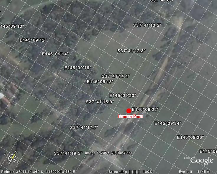
Finally most of the bugs have been ironed out of the flash memory card logging software allowing us to go flying around and actually logging the flight data. The Google Earth (TM) picture on the right shows the flying ground (with a red dot marking the launch point).

A log file was downloaded from the plane on landing from the onboard MMC card. One little bug I need to fix is printing the latitudes and longditues as signed longs - not unsigned longs (hence the very large values). But these can be easily fixed.

The data is stored in the following formats (which I created today):

For ADC sensor data:
Format: "$UAVADC,BA:720,TE:323,PR:9,AX:353,AY:453*"
BA = Battery
TE = Temperature
PR = Pressure
AX = Accelerometer X
AY = Accelerometer Y

For GPS data:
Format: "$UAVGPS,TS:1794299271,LA:-22432475,LO:73183416,AL:93,BE:315,RG:1,GG:1*"
TS = Time Stamp (multiplied by 1000
LA = Latitude (mulplied by 60000)
LO = Longitude (mulitplied by 60000)
AL = Altidude (MSL)
BE = Bearing (Degrees)
RG = RMCGood (1 = good, 0 = bad)
GG = GGAGood (1 = good, 0 = bad)

For magnetometer data
Format: "$UAVMAG,BE:321,AX:-224,AY:716*"
BE = Bearing (Degrees)
AX = Axis X value
AY = Axis Y value

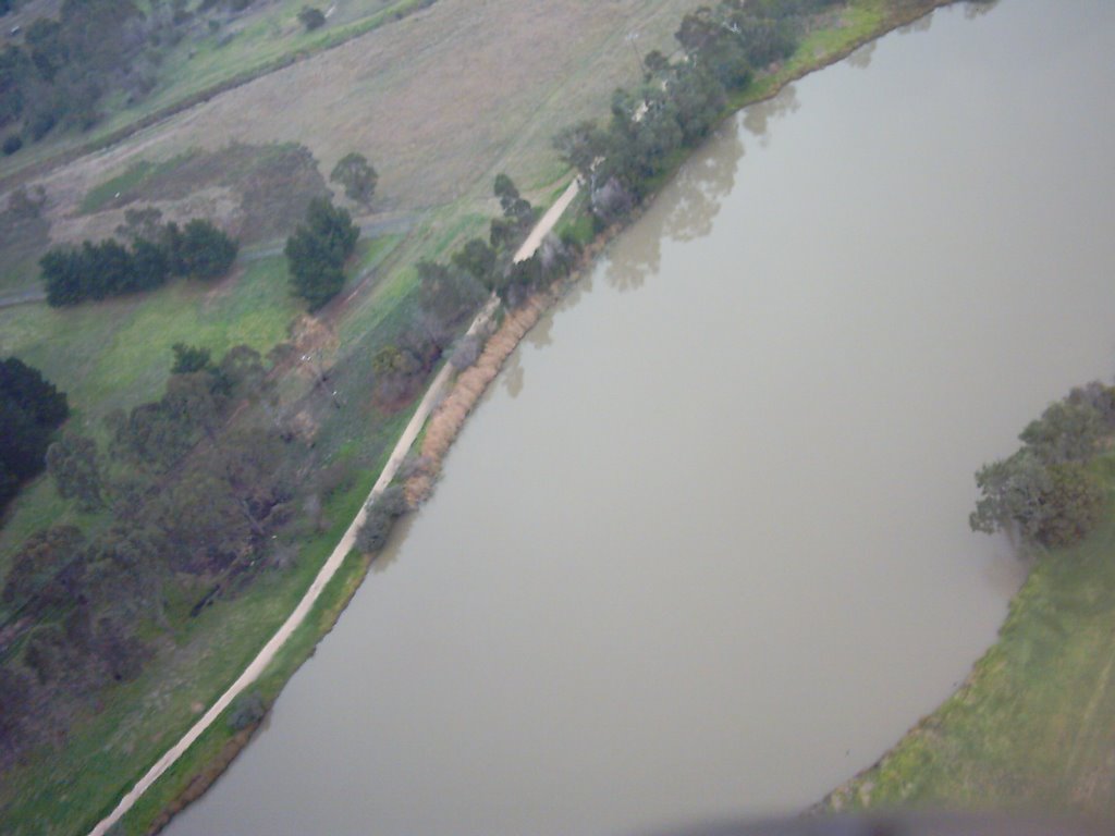
And yes - I too was pretty astounded to have got the plane upto around 300m (above ground) - I figured we would be struggling to get 150m

Magnetometres work better when magnets are not sitting on top of them

A magnetometre is a device which measures the earth's magnetic field in two axis and allows you to work out the direction of magnetic north. It basically allows you to create a 'digital compass'. Our testing involved taking measurements at 15degree increments to allow us to determine the error involved in the measurement (generally a under a couple of degrees) and also appropriate offsets to calculate a bearing measurement. That all worked well - using a compass and the diagram shown to make the measurements.


Using it in the plane is a different story through, about 3 cm above the magenetometre sits the GPS antenna - and in this configuration it gave extremely erratic results. After about 5 minutes it clicked that the antenna has a couple of magnets in the base (designed for car mounting) - when these are removed - unsurprisingly the magnetometre works again.